| Duration | 12 Days |
| Group | from 6 to 9 persons |
| Technique | |
| Endurance | |
| Costs | 748,- p.P |
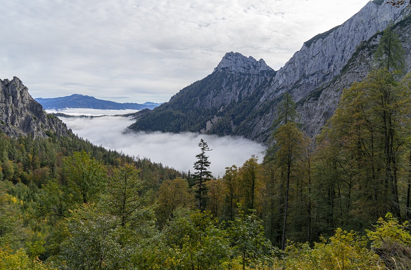
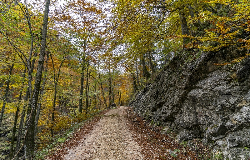
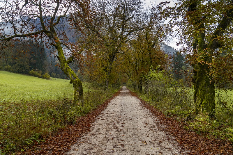
We will accompany you on this hike through impressive and varied cultural and natural landscapes. In 11 balanced stages, we cross three national parks in three different provinces. Starting in the Northern Limestone Alps National Park in Upper Austria, with its primeval beech forests, which have been designated a UNESCO World Heritage Site. On to the Gesäuse, with its rugged and imposing limestone peaks, and the Benedictine Abbey of Admont, with the world’s largest monastery library, to the Dürrenstein Wilderness Area in Lower Austria, which is home to one of the largest primeval forests in Central Europe. Likewise, that breathtaking wilderness is part of the lynx habitat! Very natural and far from any mass tourism, this long distance hiking trail will make you feel awe of Austria’s wilderness. This entire route covers 220 km and about 12,000 hm.
Dates
We offer you your desired tour with individual planning. Just contact us!
info@montinu.atMeeting point
8:00 am at the train station in Reichraming
Tour Finish
approx. 12 noon in Reichraming
Food
At lunchtime there is the possibility to stop in restaurants or huts every day. Please only bring small quantities of muesli bars (3-4). We have the possibility to buy something on the way. Bring at least 1 litre of water.
Difficulty Endurance
Endurance for tours with a walking time (pure walking time without breaks) of up to 7 hours and up to 1200 metres in altitude difference in ascent and descent.
Difficulty Technique
You should have experience in hiking and be 'sure-footed'. This means that you do not slip uncontrollably even on less good paths and that you always tread safely. The paths are usually well recognisable. The terrain is steep in parts, danger of falling cannot be ruled out if you are careless.
Services
- 11 day guided tour
- Guidance and organisation by a state-certified and local mountain hiking guide
- All expenses of the mountain guide are included
Additional Costs
- Accommodation and meals for 12 days (approx. 670 euros for bed and breakfast in a double room)
- Entrance fees and transfers approx. 70 euros
- Food and refreshments during the tour
Important Information
This is a tour with a minimum number of participants. The tour can only take place at this price if this number is reached. We will inform you as soon as we have received enough bookings.1.Day: Reichraming – Anlaufalm
| Duration | ca. 8 h |
| Technique | |
| Endurance | |
| 1004 m |
| 540 m |
| 1004 m |
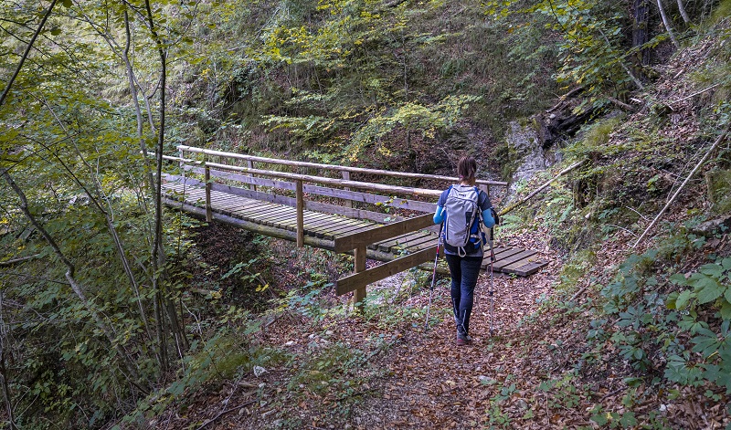
From the village of Reichraming (356 m) we first start off comfortably on forest roads into the Reichraminger Hintergebirge, one of two mountains in the Kalkalpen National Park. Through wild forests and beautiful paths, a suspension bridge and wooden footbridges, we go via the Ebenbachalm to the Klaushütte snack station (488 m). The history of the former lumberjack's hut goes back to 1758. Beech forests and with the rippling of the stream in your ear, the route repeatedly offers a great view of the natural stream landscape of the Reichramingbach. After a short rest, we continue to our destination for the day, the Anlaufalm (982 m). From there you can enjoy a magnificent view of the highest mountain of the Hintergebirge, the lonely Größtenberg (1724 m).
2.Day: Anlaufalm - Laussabaueralm
| Duration | ca. 7 h |
| Technique | |
| Endurance | |
| 805 m |
| 1100 m |
| 805 m |
From the Anlaufalm (982 m) we first go back over the alpine pasture ground we came over the day before. Then we follow a beautiful but also challenging trail down through the Hochschlacht gorge. Again and again we enjoy wonderful panoramic views of the wild forest landscape of the Kalkalpen National Park. Different forest types and also spruce stands infested by the bark beetle become visible. Passing the Schleierwasserfall and the Weißwasser bivouac site, we follow the beautiful Knappensteig trail up to the Blahbergalm (1040 m). From there we pass the fairytale-like Sieben Brünn springs and descend via the Ahornsattel (1240 m) to the Dörflermoaralm (1199 m), where the magnificent summit scenery of the Tote Gebirge (Dead Mountains) opens up. Continue down and over the Hengstpass (964 m) to the rustic Laussabaueralm (785 m), which is located under mighty lime trees that are over 300 years old.
3.Day: Laussabaueralm - Admont
| Duration | ca. 6,5 h |
| Technique | |
| Endurance | |
| 1050 m |
| 1230 m |
| 1050 m |
From the Laussabaueralm (785 m), the trail continues leisurely along the Klosterweg to the Pölztal valley. Slightly ascending and along the Pölztal stream, we pass some hunting and alpine buildings. An easy climb brings us to Klapfboden (997 m). From there we walk up a somewhat steeper path and through a fairytale forest to the small and large Seeboden, an impressive valley basin at the end of which the Admonter Haus (1894 m) is visible in a saddle. We hike through the flat valley floor and ascend the last part of the trail to the Admonter Haus. After a rest at the Admonter Haus, we descend with a view of the beautiful alpine landscape into a fairly natural forest towards Hall. Overnight stay at Landgasthof Buchner. If possible, the famous Admont Abbey with its small National Park exhibition "Passion of the Explorer" can be visited.
4.Day: Admont - Klinkehütte
| Duration | ca. 5 h |
| Technique | |
| Endurance | |
| 1294 m |
| 450 m |
| 1294 m |
From the centre of Admont (640 m) we hike in the direction of Kematen and then further into the wooded Kematengraben. Crossing a path and several forest roads, we reach the spring of the Steinernen Wirtes at the foot of the Hahnsteinkante. Here the trail becomes increasingly panoramic, leads through mountain pine fields and finally ends in the meadows of the picturesquely situated Scheiblegger Hochalm (1,660 m). From here we descend a small path with a view of the Kaiserau high valley to the Klinkehütte (1504 m).
5.Day: Klinkehütte – Johnsbach
| Duration | ca. 5,5 h |
| Technique | |
| Endurance | |
| 758 m |
| 1450 m |
| 758 m |
From the Klinkehütte we climb a few minutes to the Kalblinggatterl. From there we descend to the idyllic alpine pasture of the Flitzenalm. The rocky Admonter Reichenstein (2251 m) is a magnificent sight here. From the Hintere Flitzenalm we alternate between paths and forest roads up to the Mödlinger Hütte (1523 m). From there we enjoy the impressive landscape of the Treffneralm and the panoramic view of the peaks of Großer Ödstein (2335 m), Admonter Reichenstein and the Sparafeld (2247 m). After a rest we descend to the mountaineering village of Johnsbach. Overnight stay at the Gasthof zum Donner.
6.Day: Johnsbach - Gstatterboden - short version
| Duration | ca. 3 h |
| Technique | |
| Endurance | |
| 76 m |
| 400 m |
| 76 m |
Depending on the weather and fitness, we decide whether to do the long or short version of the 6th day. The short variant starts very comfortably with a detour to the very idyllically situated and at the same time largest mountaineers' cemetery in Austria, where the first person to die in the Gesäuse mountains was buried 200 years ago. Numerous historical gravestones tell the tragic story of many young mountaineers. From there we hike further out of the valley along the Sagenweg trail to the Weidendom adventure centre. Depending on the weather and time of day, a short detour to this is possible. Via the Rauchboden trail we continue to Gstatterboden. Along next to the wild Enns and between the steep rock faces of Buchstein, Ödstein and Hochtor, you feel like you are in the famous Yosemite Valley. A shuttle bus takes us back to the Gasthof zum Donner.
6.Day: Johnsbach - Gstatterboden - long version
| Duration | ca. 6 h |
| Technique | |
| Endurance | |
| 691 m |
| 1050 m |
| 691 m |
We hike along the Sagenweg out of the valley until we branch off to the left onto the Gsenkschartenweg. Now we climb a little more laboriously in gravelly terrain, which resembles an empty stream bed, up to the Gsengscharte. Now comes the key section \"Gsengscharte\". The last metres to the ridge are overcome here by means of a chain and rope anchored in the rock. Now we have reached the highest point (1217 m) and descend into the extremely romantic Haindlkar. Bizarre rock formations, chamois that seem almost tame and the view of the Hochtor north walls inspire our gaze. After a stop at the Haindlkarhütte (1121 m) we climb down a stony path to the Enns, freshly invigorated. Once at the bottom, we hike along the Rauchbodenweg trail to Gstatterboden. Along next to the wild Enns and between the steep rock faces of Buchstein, Ödstein and Hochtor, you feel like you are in the famous Yosemite Valley. A shuttle bus takes us back to the Gasthof zum Donner.
7.Day: Gstatterboden - Mooslandl
| Duration | ca. 6,5 h |
| Technique | |
| Endurance | |
| 1137 m |
| 1230 m |
| 1137 m |
Transfer to the starting point. The 1,000-metre ascent to the Ennstaler Hut (1543 m) begins directly in Gstatterboden. It is the oldest refuge in the Gesäuse and offers a magnificent view of the surrounding mountains. Above all, the impressive peaks of the Hochtor chain stand before us as if strung on a string of pearls. From there we descend a steep trail that leads further down through a natural mixed beech forest into the Tamischbachgraben. A forest road takes us past many apple and pear trees as well as some farms to Landl. From there we hike another 1 km to Mooslandl. Overnight stay at the Mooswirt.
8.Day: Mooslandl - Palfau
| Duration | ca. 8 h |
| Technique | |
| Endurance | |
| 904 m |
| 1000 m |
| 904 m |
From Mooswirt we hike along the "Gasteiger Rundwanderweg" towards Gams near Hieflau. The now longer and varied section of the trail offers impressive views of the valleys of the Enns and Salza rivers and leads through forests and across meadows. In Gams we come to the entrance of the impressive Nothklamm, which we will also hike through, weather permitting (entrance fee to be paid). The Nothklamm has been a natural monument since 1970. The Nothklamm, cut deep into the hard limestone, is probably one of the most impressive natural spectacles in the Styrian Limestone Alps. We hike along the 600 m long footbridge, which meanders slightly upwards and then downwards again through the wildly romantic gorge. At the exit, the only stone ball mill in Styria surprises us. At the end of the Nothklamm, a hiking trail takes us further to the Reiteralm (960 m), which is located on a saddle between Akogel (1190 m) and Grantenkogel (1297 m). From there we take a forest road through the Au- and Püllgraben to Palfau. A shuttle bus takes us back to the Mooswirt.
9.Day: Palfau - Lassing
| Duration | ca. 7 h |
| Technique | |
| Endurance | |
| 1167 m |
| 1050 m |
| 1167 m |
Transfer to the starting point. Via forest roads and forest tracks we ascend from the Stiegenwirt to the Moaralm (1550 m). This lies between the peaks of Gamsstein (1774 m) and Hasenfuß (1615 m). On hot summer days, the forest provides refreshing coolness. After a short rest at the scenic Hochalm, we first descend a forest trail and then continue hiking on a forest road to the Erlebniswelt Mendlingtal snack station. The last section through the gorge of the Mendlingbach (entrance fee to be paid), where we learn a lot about the former timber drift, is a great experience. A shuttle bus takes us back to the Mooswirt.
10.Day: Lassing – Hochreit
| Duration | ca. 8 h |
| Technique | |
| Endurance | |
| 1264 m |
| 1460 m |
| 1264 m |
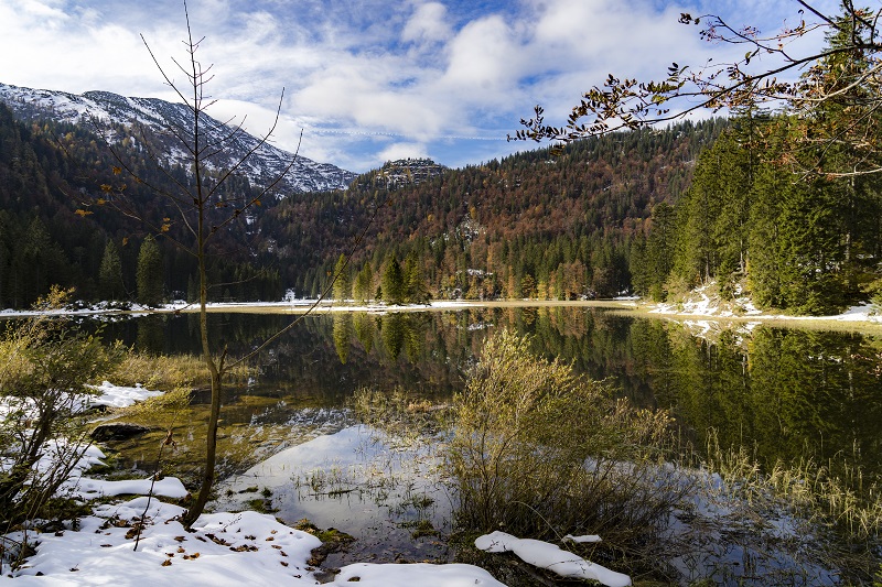
Transfer to the starting point. From Lassing we follow a hiking trail which leads through the Lassing forests to the upper Hochkarboden and to the Hochkar Schutzhaus (1,491m). From there we climb up a gravel road to Blachlboden, where a mountain lake was artificially created at the foot of the Scheiterkogel in 1998. Looking back towards the Hochkar ski area, Stumpfmauer (1770 m) and Gamsstein (1774 m) appear in the west and above the Scheinecksattel (741 m) the Haller Mauern (2244 Große Pyhrgas). The striking reddish rock (water-impermeable Liaskalke) is the cause of small pools and channels and, above all, the lush flora. We hike over several saddles, wild paths and the very charming landscape towards the Schwarzalm (1536 m). Shortly before the Schwarzalm hut, we follow a turnoff down into the highly interesting, peculiar karst landscape of the \"Kessels\". Across flowery meadows we reach the Wiesenalmhütte (1,486 m). The Wiesenalm is the most remote and scenically most beautiful alpine pasture of the Hochkarmassif. In the southwest lies the already mentioned, huge karst area of the \"Kessels\" with enormous sinkholes, cirque fields and karst alleys. From the hut we descend the moderately steep mountain ridge over a broad, flowery meadow ridge with a view of the Dürrenstein (1878 m). Past the beautifully situated Leckermoor, we continue to the Hochreit plateau and our destination for the day, the Ablaß farm (832 m), which is well worth a visit. Overnight stay at the Mooswirt.
11.Day: Hochreit - Lunz
| Duration | ca. 9,5 h |
| Technique | |
| Endurance | |
| 1396 m |
| 1470 m |
| 1396 m |
A shuttle takes us to the Steinbachtal valley to the car park of the normal ascent of the Ybbstaler Hütte. From there we walk up 730 metres in altitude on forest roads and uphill paths to the hut. From the hut we hike in a south-easterly direction through a gently ascending, sparsely wooded karst dry valley. The trail climbs moderately past several karst hollows and sinkholes, then somewhat steeper to the Legsteinalm (1440 m). Here we are in the north-eastern part of the Dürrenstein Wilderness Area, which covers a total area of about 3,500 ha. The core area of this international protected area, the primeval forest Rothwald, is the largest primeval forest remnant in Central Europe and a strict nature reserve. The stony path leads over karstified terrain through mountain pine alleys up to a high plateau where we reach the summit of the Dürrenstein (1,878 m), which is adorned with a beautiful iron cross. The magnificent panorama of the summit tempts us to take an extended rest. The descent to the Leonhardikreuz (1,406m) first leads through mountain pines and later across the alpine meadows of the Herrenalm. The trail descends steeply from the Leonhardikreuz to the idyllic and picturesque Obersee lake - a natural gem! Afterwards, the trail leads along a forest road through the wild and romantic Seetal valley. Past the interesting karst phenomenon of the "Brüllender Stiers" (underground waterfall), the Ludwigfall and the Mittersee, we hike through the Seetal out to the Seehof hiking starting point at Lake Lunz. A shuttle takes us to our accommodation, Zellerhof.